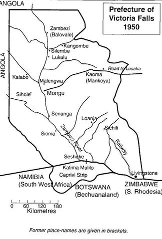
Item 94 - Map of the Prefecture of Victoria Falls

Open original Digital object

Reference code

IE CA AMI/2/10/3/94

Title

Map of the Prefecture of Victoria Falls

Date(s)

  • 1950 (Creation)

Level of description

Item

Extent and medium

Black and white print; TIFF file

Name of creator

Archival history

Immediate source of acquisition or transfer

Scope and content

A map of the Prefecture of Victoria Falls showing the locations of Irish Capuchin mission stations in 1950. The former place names are given in brackets such as Kaoma (formerly Mankoya).

Appraisal, destruction and scheduling

Accruals

System of arrangement

Conditions governing access

Conditions governing reproduction

Language of material

    Script of material

      Language and script notes

      Physical characteristics and technical requirements

      Finding aids

      Existence and location of originals

      Existence and location of copies

      Related units of description

      Related descriptions

      Alternative identifier(s)

      Subject access points

      Place access points

      Name access points

      Genre access points

      Description identifier

      Institution identifier

      Rules and/or conventions used

      Status

      Level of detail

      Dates of creation revision deletion

      Language(s)

        Script(s)

          Sources

          Digital object (Master) rights area

          Digital object (Reference) rights area

          Digital object (Thumbnail) rights area

          Accession area