Código de referência
Título
Data(s)
- c.1930 (Produção)
Nível de descrição
Dimensão e suporte
Glass Plate Negative; 10.6 cm x 8.2 cm
Nome do produtor
Entidade detentora
História do arquivo
Fonte imediata de aquisição ou transferência
Âmbito e conteúdo
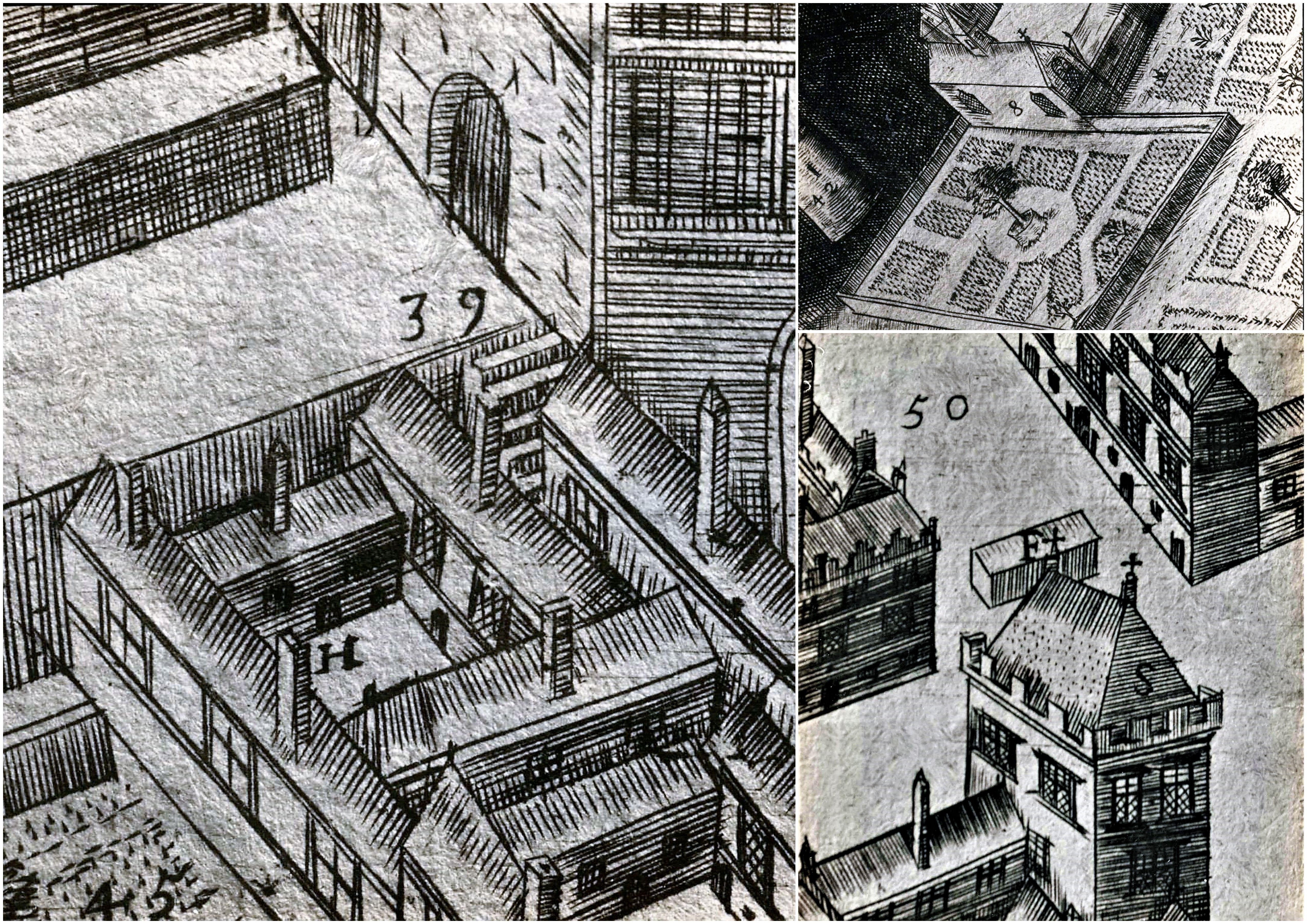
A file containing ‘Wellington Plates’ box. The box holds four plates showing details from a pictorial map of Galway (c.1651). Two known copies of the original seventeenth century map exist, one in Trinity College Library in Dublin, and the second in the James Hardiman Library in NUI Galway.
The numbered map details include references to the following:
H. This is described on the map as the ‘Residentia Capuchinorum’. It represents a block of buildings on the north side of Great Gate Street in an area now known as Williamsgate Street. It sits under one of the Great Gates of the city (marked as ‘30’). It is most likely the location of the rented house occupied by the Capuchins in 1644 when they left the Collegiate buildings of St. Nicholas.
F. This indicates the altar erected by the Capuchins for public processions along the main thoroughfare running through Galway. The altar was situated at a place now popularly referred to as the ‘The Four Corners’, at one of which is the well-known fourteenth century stone townhouse called Lynch’s Castle (marked as ‘S’).
Number '8' on the map is a reference to a church, a block of buildings and an ornamental garden with walks. It is referred to on the map as ‘Capuchinorum Aedes’. It is situated outside the city walls and stands on the north side of Bohermore – now known as Prospect Hill. It is located near the old Pigeon House (marked as ‘42’). This is most likely the church and friary built by the Capuchins when they vacated their rented house in 1644. The site of this church is now occupied by The Western Hotel.
Avaliação, seleção e eliminação
Incorporações
Sistema de arranjo
Condições de acesso
Condiçoes de reprodução
Idioma do material
Sistema de escrita do material
Notas ao idioma e script
Características físicas e requisitos técnicos
Instrumentos de descrição
Existência e localização de originais
Existência e localização de cópias
Unidades de descrição relacionadas
Nota de publicação
These plates were acquired by Fr. Angelus Healy OFM Cap. for his article on the Capuchins in Galway. This article was published in ‘The Capuchin Annual’ (1935), pp 230-3. http://annual.capuchinfranciscans.ie/1935/html5/
Nota
Further contextual information on this seventeenth century map of Galway can be found at https://library.nuigalway.ie/digitalscholarship/projects/17th-century-map-of-galway-city/
Nota
See the interactive digitized copy of this map at https://digital.library.nuigalway.ie/islandora/object/nuigalway%3A31891