Código de referência
Título
Data(s)
- c.1900 (Produção)
Nível de descrição
Dimensão e suporte
59 cm x 33 cm; Ink with colour washes on trace paper; typescript
Nome do produtor
Entidade detentora
História do arquivo
Fonte imediata de aquisição ou transferência
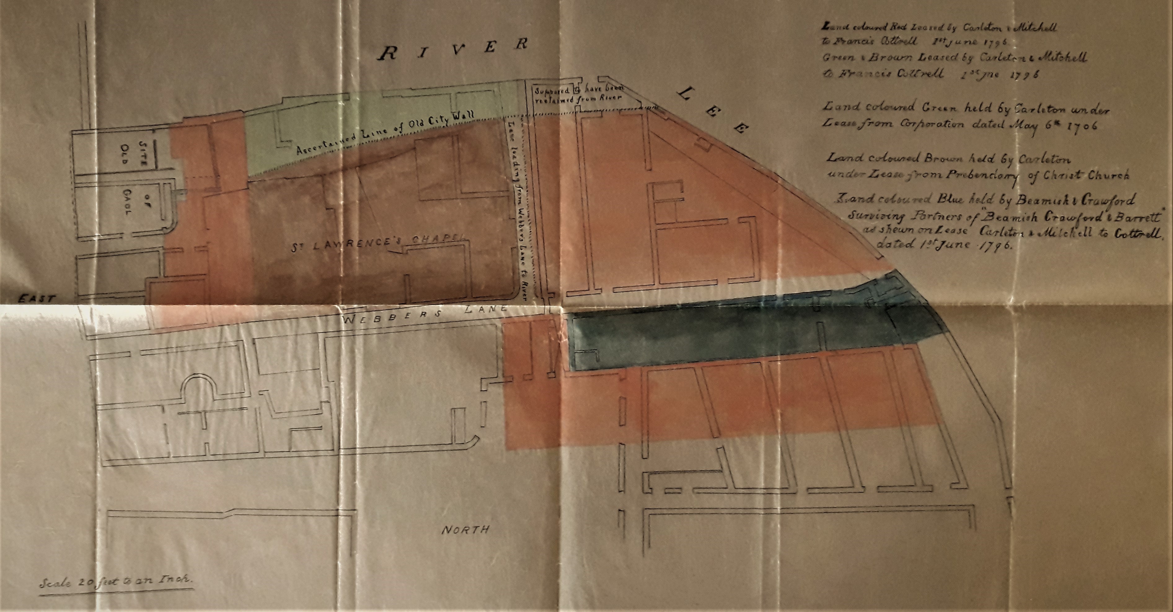
Âmbito e conteúdo
Copy map showing outline of the medieval St. Lawrence’s Chapel near the South Channel of the River Lee. The chapel is bounded by Webber’s Lane (now Morgan’s Lane) and by the ‘ascertained line of the Old City Wall’. The site was seemingly covered by the recently-demolished former Beamish & Crawford Brewery, Main Street South, Cork. The map was probably copied from a nineteenth-century lease map and has the following key to the coloured areas:
‘Land coloured red leased by Carleton & Mitchell to Francis Cottrell, 1st June 1796.
Green and brown leased by Carleton & Mitchell to Francis Cottrell, 1st June 1796.
Land coloured green held by Carleton under lease from Corporation dated May 6th 1706.
Land coloured brown held by Carleton under lease from Prebendary of Christ Church.
Land coloured blue held by Beamish & Crawford, surviving partners of “Beamish, Crawford & Barrett” as shewn on lease [of] Carleton & Mitchell to Cottrell dated 1st June 1796’.
With a typescript note by Fr. Angelus Healy OSFC on the history of St. Lawrence’s Church.
Avaliação, seleção e eliminação
Incorporações
Sistema de arranjo
Condições de acesso
Condiçoes de reprodução
Idioma do material
Sistema de escrita do material
Notas ao idioma e script
Características físicas e requisitos técnicos
Instrumentos de descrição
Existência e localização de originais
Existência e localização de cópias
Unidades de descrição relacionadas
Nota
See also Maurice F. Hurley, 'A Case Study in Archaeology and Public Benefit from an Urban Excavation in an Old Brewery: Cork City, Ireland', 'Internet Archaeology' 57. (2021) https://intarch.ac.uk/journal/issue57/5/full-text.html