- IE CA AMI/1/9
- Subseries
- 1933-c.1940
Part of Irish Capuchin Archives
3018 results with digital objects Show results with digital objects
Part of Irish Capuchin Archives
Part of Irish Capuchin Archives
This sub-series contains plans, drawings and architectural and engineering specifications and blueprints for properties and premises acquired by the Capuchins in Cork.
Part of Irish Capuchin Archives
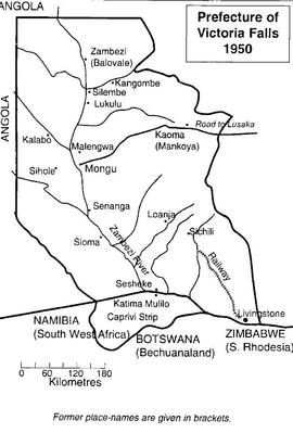
Map of the Prefecture of Victoria Falls
Part of Irish Capuchin Archives
A map of the Prefecture of Victoria Falls showing the locations of Irish Capuchin mission stations in 1950. The former place names are given in brackets such as Kaoma (formerly Mankoya).
Map of the Four Provinces of Ireland
Part of Irish Capuchin Archives
Colour maps of the four provinces of Ireland. The maps are probably inserts from a school textbook.
Part of Irish Capuchin Archives
No scale given
Copy map showing principal settlements and geographic and physical features of the Caprivi Strip bordered to the east by Zambia and to the west by Angola and Botswana. Attention is paid to the locations of mission stations and education establishments including at Katima Mulilo (founded by the Irish Capuchins) which has Mauvluma primary and Negweze schools.
Part of Irish Capuchin Archives
Scale: 4 miles to 1 inch
The Royal Automobile Club of South Africa / Map of the Cape Peninsula. The map has been annotated (in red ink) with the locations and names of Irish Capuchin missions in the Cape Province (Parow, Langa and Claremont).
Map of schools in South-Western Zambia
Part of Irish Capuchin Archives
Copy map showing the approximate locations of primary and secondary schools in south-western Zambia and in the Caprivi Strip. The list includes Katima Mulilo Primary School, Kizito College and Ngweze Secondary School.
Map of mission stations in Barotseland
Part of Irish Capuchin Archives
Map of mission stations, out-schools in Barotseland primarily located along the Zambezi River. The location of local magistrate buildings and Protestant mission stations and schools is also given. The principal Irish Capuchin stations shown are Sancta Maria (Lukulu), Mongu, Schilli, Mankoya, and Livingstone.
Part of Irish Capuchin Archives
Scale: 1 inch to 500,000 kms
Map of Kafue National Park in the Republic of Zambia. The map was published by the Zambian National Tourist Board in Lusaka.