- IE CA AMI/2/10/3/169
- Item
- c.1970
Part of Irish Capuchin Archives
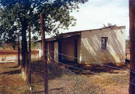
The exterior of the first friary at Maramba in Zambia.
245 results with digital objects Show results with digital objects
Part of Irish Capuchin Archives
The exterior of the first friary at Maramba in Zambia.
Part of Irish Capuchin Archives
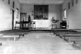
The interior of the church at the Christ the King mission at Maramba, Northern Rhodesia.
Part of Irish Capuchin Archives
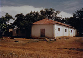
The exterior of the first church at Maramba built by Br. Dominic O’Callaghan OFM Cap.
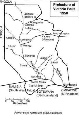
Map of the Prefecture of Victoria Falls
Part of Irish Capuchin Archives
A map of the Prefecture of Victoria Falls showing the locations of Irish Capuchin mission stations in 1950. The former place names are given in brackets such as Kaoma (formerly Mankoya).
Part of Irish Capuchin Archives
No scale given
Copy map showing principal settlements and geographic and physical features of the Caprivi Strip bordered to the east by Zambia and to the west by Angola and Botswana. Attention is paid to the locations of mission stations and education establishments including at Katima Mulilo (founded by the Irish Capuchins) which has Mauvluma primary and Negweze schools.
Map of schools in South-Western Zambia
Part of Irish Capuchin Archives
Copy map showing the approximate locations of primary and secondary schools in south-western Zambia and in the Caprivi Strip. The list includes Katima Mulilo Primary School, Kizito College and Ngweze Secondary School.
Map of mission stations in Barotseland
Part of Irish Capuchin Archives
Map of mission stations, out-schools in Barotseland primarily located along the Zambezi River. The location of local magistrate buildings and Protestant mission stations and schools is also given. The principal Irish Capuchin stations shown are Sancta Maria (Lukulu), Mongu, Schilli, Mankoya, and Livingstone.
Part of Irish Capuchin Archives
Scale: 1 inch to 500,000 kms
Map of Kafue National Park in the Republic of Zambia. The map was published by the Zambian National Tourist Board in Lusaka.
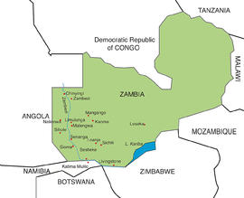
Map of Irish Capuchin Mission Stations in Zambia
Part of Irish Capuchin Archives
Colour map showing the locations of present-day and former Irish Capuchin mission stations and foundations in the Western Province of Zambia (formerly known as Barotseland in the colonial era).
Part of Irish Capuchin Archives
Scale: 47.4 miles to 1 inch
Printed map of Barotseland, Northern Rhodesia, showing the principal districts and the Irish Capuchin mission stations primarily along the Zambezi River including Mongu, Sesheke and Katima Mulilo. The map is probably extracted from a government publication.