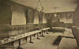
The Refectory, Capuchin Friary, Kilkenny
- IE CA CP/1/1/2/1/4
- Parte
- c.1930
Parte deIrish Capuchin Archives
The refectory in the Capuchin Friary (Walkin Street, later Friary Street), Kilkenny.
The Refectory, Capuchin Friary, Kilkenny
Parte deIrish Capuchin Archives
The refectory in the Capuchin Friary (Walkin Street, later Friary Street), Kilkenny.
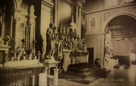
The Sanctuary, Church of St. Francis, Capuchin Friary, Kilkenny
Parte deIrish Capuchin Archives
The sanctuary in the Church of St. Francis, Capuchin Friary, Kilkenny.
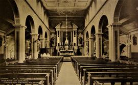
The Interior of the Church of St. Francis, Capuchin Friary, Kilkenny
Parte deIrish Capuchin Archives
The interior of the Church of St. Francis, Capuchin Friary, Kilkenny.
Parte deIrish Capuchin Archives
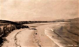
A postcard print of Inch Strand, County Kerry, in c.1930.
Parte deIrish Capuchin Archives
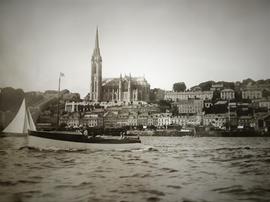
A view of Cobh Harbour in County Cork. The Cathedral Church of St. Colman is prominent in the image.
Parte deIrish Capuchin Archives
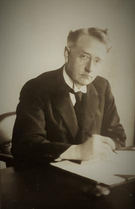
A photographic print of W.T. Cosgrave (1880-1865), President of the Executive Council of the Irish Free State.
Parte deIrish Capuchin Archives
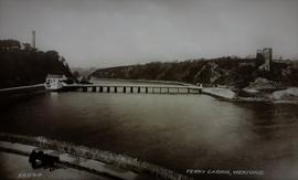
A postcard print of the ruined fifteenth-century tower house and on the left the Round Tower (the Crimea War Monument) at Ferrycarrig in County Wexford.
Parte deIrish Capuchin Archives
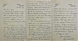
A letter from Eoin MacNeill (1867-1945) to Fr. Henry Rope. MacNeill argues that Roger Casement was 'remarkably sane and well balanced' and affirms that he had 'no opportunity of consulting with him' as he was in America when war broke out. MacNeill also refers to his Irish history scholarship and to his work as chairman of the Irish Manuscripts Commission.
Parte deIrish Capuchin Archives
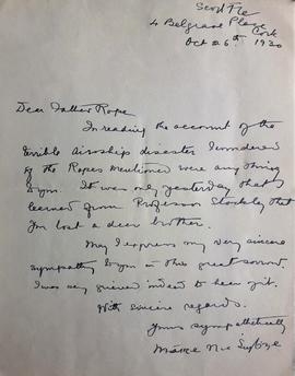
Letters from Mary MacSwiney (Máire Nic Shuibhne, 1872-1942) to Fr. Henry Rope. Two of the letters are copies (Rope notes that the copies were made in 1947 and that he deposited the originals in the archives of the Pontifical Irish College in Rome). One of the copy letters (dated 21 Nov. 1922) refers to Mary MacSwiney’s treatment by the Free State authorities. It reads ‘The hardest part of my trial here is being deprived of the Sacraments as I have not succeeded in finding a priest who will be satisfied to hear the confession of my sins and let my political convictions alone’. The original letter (26 Oct. 1930) refers to the ‘terrible airship disaster’ involving R 101, a British rigid airship. The disaster claimed the lives of forty-eight of the fifty-four people on board including Fr. Henry Rope’s younger brother, Squadron Leader Frederick Michael Rope.
Parte deIrish Capuchin Archives
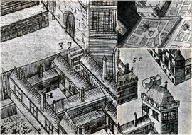
A file containing ‘Wellington Plates’ box. The box holds four plates showing details from a pictorial map of Galway (c.1651). Two known copies of the original seventeenth century map exist, one in Trinity College Library in Dublin, and the second in the James Hardiman Library in NUI Galway.
The numbered map details include references to the following:
H. This is described on the map as the ‘Residentia Capuchinorum’. It represents a block of buildings on the north side of Great Gate Street in an area now known as Williamsgate Street. It sits under one of the Great Gates of the city (marked as ‘30’). It is most likely the location of the rented house occupied by the Capuchins in 1644 when they left the Collegiate buildings of St. Nicholas.
F. This indicates the altar erected by the Capuchins for public processions along the main thoroughfare running through Galway. The altar was situated at a place now popularly referred to as the ‘The Four Corners’, at one of which is the well-known fourteenth century stone townhouse called Lynch’s Castle (marked as ‘S’).
Number '8' on the map is a reference to a church, a block of buildings and an ornamental garden with walks. It is referred to on the map as ‘Capuchinorum Aedes’. It is situated outside the city walls and stands on the north side of Bohermore – now known as Prospect Hill. It is located near the old Pigeon House (marked as ‘42’). This is most likely the church and friary built by the Capuchins when they vacated their rented house in 1644. The site of this church is now occupied by The Western Hotel.