Affichage de 190 résultats

Description archivistique
Avec objets numériques Glass Plate Negative and Lantern Slide Collection
Aperçu avant impression Hierarchy Affichage :

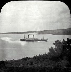
'Oceanic' Liner leaving Cork Harbour

A view of the White Star Liner ‘Oceanic’ leaving Queenstown (now Cobh) Harbour in 1905. Launched in 1899, it was largest ship in the world until 1901. At the outbreak of the First World War, the ship was requisitioned for service in the Royal Navy as an armed merchant cruiser. In September 1914, the ship ran aground off the coast of Shetland and was wrecked. She was the first Allied passenger ship to be lost in the war.

Fr. Mathew Inaugurates Temperance Campaign

A lantern slide showing a print of Fr. Theobald Mathew OSFC addressing a committee. The print is captioned ‘Here goes, in the name of God!, Fr. Mathew inaugurates the temperance campaign on 10 April 1838'. The drawing is by Denis Santry (1879-1960).

Father Mathew Pavilion, Cork International Exhibition

A view of the interior of the Father Mathew Pavilion at the Cork International Exhibition of 1902. The image shows a large decorative banner and models of Holy Trinity Church in Cork, and Thomastown Castle, County Tipperary, the childhood home of Fr. Mathew. The plate is captioned.

Portrait of Fr. Theobald Mathew OSFC

A plate showing a portrait of Fr. Theobald Mathew OSFC (as a younger man). The portrait shows Fr. Mathew in traditional nineteenth-century clerical attire with a temperance medal pinned to his breast.

Father Mathew addressing a Temperance Demonstration

A plate of a print titled ‘Father Mathew addressing a temperance meeting in London’. The plate by T. Mayne & Son, Dublin. The original print shows Fr. Mathew preaching in London in 1843 taken from 'The Illustrated London News' (August 1843).

Map and Views of Charleville (now Charleville-Mézières) and Sedan, France

The file comprises ‘The Imperial Dry Plate Co., Ltd., Cricklewood, London’ box. The box contains three plates. One of the plates shows an image of a seventeenth century map of the town of Charleville (now Charleville-Mézières) in the Ardennes Department in Northern France. The map shows the location of the church and friary established by the exiled Irish Capuchins in Charleville in the early seventeenth century. The map is titled ‘Charleville sur le Bord de la Meuze dans la Principaute Souuerain Darches’. The map has been attributed to Edmé Moreau (1596-1648). The file also includes topographic views of the walled cities of Sedan and Tovl. A faint ink stamp of the British Museum is visible on the Sedan view. Includes a cover letter from Alan Macbeth, photographers, affirming that the prints were sourced from the ‘Zeillers Topographie Gallae’ collection in the British Museum. The letter is dated 2 January 1920.

Résultats 41 à 50 sur 190