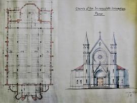
No scale given Sectional plan and front-view elevation of the proposed Church of the Immaculate Conception in Parow, Cape Town, South Africa. The plan is initialed ‘GA’ and is dated 19 January 1935.
Scale: 5 miles to 1 inch Map of the Cape Province, South Africa, by the Roads Branch, Cape Provincial Administration. With mileage table in both Afrikaans and English. Manuscript additions to the map (in pencil) roughly indicate the location of the Irish Capuchin churches in the Cape Province: Langa, Athlone, Parow, the Welcome Estate and Matroosfontein. A distinction is made between locations with both churches and mission schools and areas where only a school is present. A manuscript stamp indicates that the map was sent to Fr. Edwin Fitzgibbon OFM Cap., Provincial Minister, St. Bonaventure’s Friary, Cork.
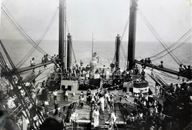
An image captioned 'Dominion Monarch / 1947'. The photograph shows a line-crossing ceremony on the ship, an initiation rite that commemorates a person's first crossing of the Equator. Built in England between 1937 and 1939, the 'Dominion Monarch' was a passenger liner which regularly operated services between Britain and ports in the southern hemisphere (particularly in South Africa, Australia and New Zealand).
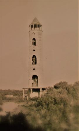
A view of a replica Irish Round Tower located in the Philippi area of the Flats region near Cape Town in South Africa. The tower (formally known as St. Patrick’s Shrine) was built on the slopes of Table Mountain which overlooks the city of Cape Town. The tower was constructed by Fr. James Kelly, an Irish Catholic missionary. The tower was a noted landmark in the Cape Flats district and acted as a focal point for annual St. Patrick’s Day’s festivities for Cape Town’s Irish community with the spire bedecked with national colours. The tower was demolished in 1978.