Showing 190 results

Archival description
With digital objects Glass Plate Negative and Lantern Slide Collection
Print preview Hierarchy View:

Letters of Fr. Robert O’Connell OSFC (c.1623-1678)

A file containing ‘Criterion Plates Ltd., Stechford, Birmingham’ box. The box holds four plates. The annotation on the box reads ‘Negatives of letters of Fr. Robert O’Connell OSFC in the Fr. Luke Wadding OFM [1588-1657] collection'. The annotation was made by Fr. Stanislaus Kavanagh OFM Cap. in May 1922. The plates are labelled a-d.

Map of Galway (c.1651)

A file containing ‘Wellington Plates’ box. The box holds four plates showing details from a pictorial map of Galway (c.1651). Two known copies of the original seventeenth century map exist, one in Trinity College Library in Dublin, and the second in the James Hardiman Library in NUI Galway.

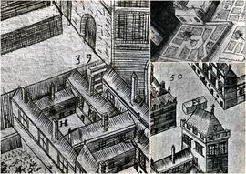
The numbered map details include references to the following:

H. This is described on the map as the ‘Residentia Capuchinorum’. It represents a block of buildings on the north side of Great Gate Street in an area now known as Williamsgate Street. It sits under one of the Great Gates of the city (marked as ‘30’). It is most likely the location of the rented house occupied by the Capuchins in 1644 when they left the Collegiate buildings of St. Nicholas.

F. This indicates the altar erected by the Capuchins for public processions along the main thoroughfare running through Galway. The altar was situated at a place now popularly referred to as the ‘The Four Corners’, at one of which is the well-known fourteenth century stone townhouse called Lynch’s Castle (marked as ‘S’).

Number '8' on the map is a reference to a church, a block of buildings and an ornamental garden with walks. It is referred to on the map as ‘Capuchinorum Aedes’. It is situated outside the city walls and stands on the north side of Bohermore – now known as Prospect Hill. It is located near the old Pigeon House (marked as ‘42’). This is most likely the church and friary built by the Capuchins when they vacated their rented house in 1644. The site of this church is now occupied by The Western Hotel.

Textile Mill near Rochestown, County Cork

A view of the textile mill on the road to Rochestown on the outskirts of Cork city in about 1905. It is possible that the image shows one of the many textile mills which operated in the Douglas area of Cork at the beginning of the twentieth century. Douglas began to develop as an urban settlement in the early eighteenth century. The mills produced sailcloth and supplied sails to the Royal Navy among other clients.

On the roadside near Rochestown, County Cork

Two glass plates titled ‘On the roadside, Rochestown’. The cover annotation provides a date of 1906. The image is of two women (possibly a mother and daughter) greeting a group a children on a wooded path. The same women appear in the photograph at CA PH-1-29-D.

Railway Station, Rochestown, County Cork

A view of a group of people (including the station master and children) at the Rochestown Railway Station, County Cork. The annotated cover reads ‘Group at Rochestown Station before completion of loop line’.

Mageney Railway Station, County Kildare

A view of four individuals working on the train line at Mageney Railway Station, County Kildare, in about 1910. Opened in 1846, the station formed part of the Great Southern and Western Railway line from Cherryville Junction to Kilkenny.

Two Women on a Forested Hillside

Two women (one sitting and holding a jug) on a forested hillside. The standing girl appears to be collecting berries. The image was probably taken near the Capuchin Friary in Rochestown, County Cork.

Results 51 to 60 of 190