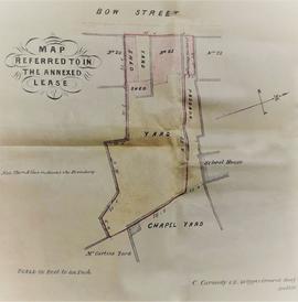
Lease by William John Russell, Mountjoy Square, to Fr. Daniel O’Reilly OSFC, Fr. David Thomas Ashe OSFC, and Fr. Edmund Dillon OSFC, North King Street, of a parcel of ground and shed ‘formerly known as numbers “21” and “22” but now known as number “21” … situated on the east side of Bow Street … [with] the adjoining Chapel Yard’. The term is specified as fifty-nine years and the annual rent is £24 to be paid in two yearly half payments. With a coloured sketch map showing the premises referred to in the lease. The sketch map was complied by C. Carmody, 20 Upper Ormond Quay, Dublin. Scale: 20 feet to an inch.
The file contains the following editions of this newspaper published in Kilkenny: 21 Mar. 1863 (Vol. XXXIV, No. 3,343) 27 Dec. 1867 (Vol. XXXVIII, No. 3,391) The latter edition has a manuscript annotation ‘Mr. Bibby’ referring to an article penned by ‘the nephew alluded to’ relating to the presence of a Catholic clergyman at his uncle’s bedside during his final illness.
Assignment of Thomas Hewat, William Street, Dublin, trustee on behalf of the Provincial Bank of Ireland, to George Thornton Adams, merchant, Cork, of the residue of a lease of premises on Queen Street dated 1 Jan. 1846 (see CA HT/2/1/1/9) in consideration of £250.
Scale: 20 feet to 1 inch Plan of premises at 21 Bow Street demised to the Capuchin friars drawn by C. Carmody, C.E., 29 Upper Ormond Quay, Dublin. The plot is bounded to north by 22 Bow Street, a passage way and a school house, and to the east by the Chapel Yard and Curtins’ Yard. The frontage onto Bow Street measures 38 feet 4 inches. An annotation on the reverse reads: ‘map of premises on Church Street upon part of which the Church Street Chapel is built’.
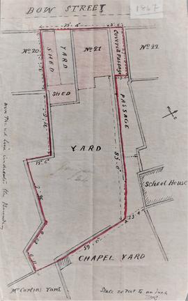
Scale: 20 feet to 1 inch Plan delineating the boundary of demised house, yards and shed at 21 Bow Street. The plot is bounded to north by 22 Bow Street, a passage way and a school house, and to the east by the Chapel Yard and Curtins’ Yard. The frontage onto Bow Street measures 38 feet 4 inches. An annotation in the left-hand margin of the plan reads: ‘The red line indicates the boundary’.