- IE CA AMI/2/10/3/309
- Item
- c.2006
Part of Irish Capuchin Archives
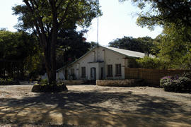
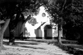
The exterior of Mangango Capuchin Friary, Zambia.
Part of Irish Capuchin Archives
The exterior of Mangango Capuchin Friary, Zambia.
Part of Irish Capuchin Archives
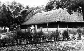
The exterior of Mangango Friary. The original caption reads ‘1948 moved from Mukunkiki to Mangango: Br. Gabriel McGillicuddy OFM Cap. the builder. The first friary was a pole and dagga construction’.
Part of Irish Capuchin Archives
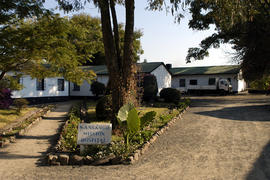
The exterior (rear-view) of Mangango Capuchin Friary, Zambia.
Part of Irish Capuchin Archives
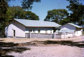
The exterior of Mangango Mission Hospital, Zambia.
Part of Irish Capuchin Archives
The exterior of Mangango Parish Church (built by Br. Gabriel McGillicuddy OFM Cap.).
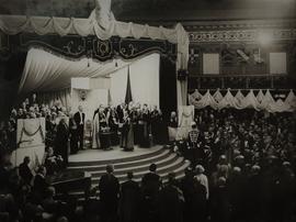
Mansion House Ceremony, Eucharistic Congress, Dublin
Part of Irish Capuchin Archives
An image of official ceremony at the Mansion House in Dublin during the 31st International Eucharistic Congress. The Lord Mayor of Dublin, Alfie Byrne (1882-1956), is in attendance.
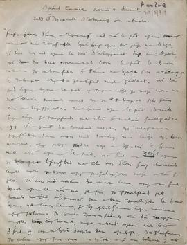
Manuscript Copy of Robert Emmet’s Speech by Terence MacSwiney
Part of Irish Capuchin Archives
Manuscript transcript of Robert Emmet’s ‘Speech from the dock’ (1803) by Terence MacSwiney. The text is a copy by MacSwiney of an Irish translation of Emmet’s speech made by Tadhg Ó Murchadha (‘Seandún’). The text was later bound into a volume by Br. Senan Moynihan OFM Cap. Gilt title to spine reads ‘Manuscript copy by Terence MacSwiney of Robert Emmet’s speech’. A manuscript addition suggests that the original translation by Ó Murchadha was published in ‘Fáinne an Lae’ in May 1899.
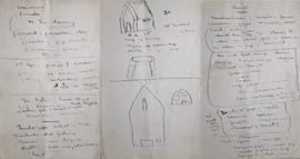
Manuscript Notes on Irish Saints by Patrick Pearse
Part of Irish Capuchin Archives
Notes in both English and Irish probably written by Patrick Pearse. Includes a sketch, possibly of the medieval Christian monastery on St. Macdara’s Island off the coast of County Galway. Also includes references to St. Enda, a sixth-century saint who founded a Christian monastic settlement on Inis Mór, and Mochuda of Lismore who ‘did fishing’.
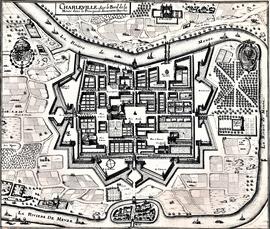
Map and Views of Charleville (now Charleville-Mézières) and Sedan, France
Part of Irish Capuchin Archives
The file comprises ‘The Imperial Dry Plate Co., Ltd., Cricklewood, London’ box. The box contains three plates. One of the plates shows an image of a seventeenth century map of the town of Charleville (now Charleville-Mézières) in the Ardennes Department in Northern France. The map shows the location of the church and friary established by the exiled Irish Capuchins in Charleville in the early seventeenth century. The map is titled ‘Charleville sur le Bord de la Meuze dans la Principaute Souuerain Darches’. The map has been attributed to Edmé Moreau (1596-1648). The file also includes topographic views of the walled cities of Sedan and Tovl. A faint ink stamp of the British Museum is visible on the Sedan view. Includes a cover letter from Alan Macbeth, photographers, affirming that the prints were sourced from the ‘Zeillers Topographie Gallae’ collection in the British Museum. The letter is dated 2 January 1920.
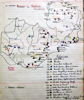
Map of Christian Missionary Stations in Northern Rhodesia
Part of Irish Capuchin Archives
A manuscript map showing the locations of stations and churches founded by Christian (mainly Protestant) denominations in Northern Rhodesia (now Zambia). A reference key gives the dates of arrival of the various congregations and groups in the country. The map is extant on p. 11 in the volume.