
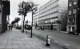
An image of South Mall in Cork. The large office block (on the right) is the Irish Life building.
A view of a street in Gurranabraher, a residential suburb on the north western side of Cork. The street is Cathedral Road in Gurranabraher. A manuscript annotation on the reverse of the print reads 'Gurranabraher / Red City'.
An image of Verolme Dockyard in Cork Harbour at Rushbrooke near Cobh.
A postcard captioned ‘Bridge Street, Belturbet. (From Kilconny Bridge)’ in County Cavan. The card was published by McGrath, stationer, Belturbet.
A view of Nelson’s Pillar on O'Connell Street as seen from Henry Street, Dublin, in 1964.
A photograph of the Sugar Beet factory in County Carlow in April 1931.
A view of the Chaine Memorial Tower on the shores of Larne Lough, County Antrim, in about 1935.
A view of the Monk’s Fishing House on the River Cong in County Mayo in about 1940. Situated not far from the site of the former Augustinian Abbey of Cong, this small stone structure probably dates to the early sixteenth century. The fishing house is located on an island on the River Cong leading towards nearby Lough Corrib. It is built on a platform of stones over a small arched opening which allows the river to flow underneath the floor. A trapdoor in the floor is thought to have been used for a net to catch fish. It is believed a line connected the fishing house to the monastery kitchen to alert the monks to a fresh catch.
A postcard print of Belfast City Hall issued by the Ulster Tourist Development Association (UTDA), 6 Royal Avenue, Belfast.
A view of the Dominican College in Newbridge on the banks of the River Liffey in County Kildare in about 1945.