No scale given Copy map showing principal settlements and geographic and physical features of the Caprivi Strip bordered to the east by Zambia and to the west by Angola and Botswana. Attention is paid to the locations of mission stations and education establishments including at Katima Mulilo (founded by the Irish Capuchins) which has Mauvluma primary and Negweze schools.
Scale: 4 miles to 1 inch The Royal Automobile Club of South Africa / Map of the Cape Peninsula. The map has been annotated (in red ink) with the locations and names of Irish Capuchin missions in the Cape Province (Parow, Langa and Claremont).
Copy map showing the approximate locations of primary and secondary schools in south-western Zambia and in the Caprivi Strip. The list includes Katima Mulilo Primary School, Kizito College and Ngweze Secondary School.
Map of mission stations, out-schools in Barotseland primarily located along the Zambezi River. The location of local magistrate buildings and Protestant mission stations and schools is also given. The principal Irish Capuchin stations shown are Sancta Maria (Lukulu), Mongu, Schilli, Mankoya, and Livingstone.
Scale: 1 inch to 500,000 kms Map of Kafue National Park in the Republic of Zambia. The map was published by the Zambian National Tourist Board in Lusaka.
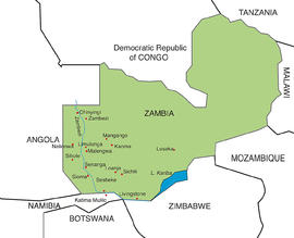
Colour map showing the locations of present-day and former Irish Capuchin mission stations and foundations in the Western Province of Zambia (formerly known as Barotseland in the colonial era).
The item is titled a ‘Rough map of premises on Church Street and Bow Street, Dublin, the property of the Capuchin Fathers’ by John L. Robinson, architect, 198 Great Brunswick Street, Dublin. The properties and lots are annotated with information relating to the dates and parties involved in various transactions. The parties included John Jameson, Viscount de Vesci and John Magrane. Information is given in respect of nos. 133-4 and 142 Church Street.
No scale given Fragmentary map of Cape Government Railways / The Royal Mail Route to the Orange River Colony, Transvaal, and Rhodesia. The map was printed by McCorquodale Ltd., Map Engravers, London. The map shows the principal railways in British possessions in Southern Africa including the Cape Colony, the Orange River Colony, Natal, Rhodesia (Zimbabwe) to the borders of Northern Rhodesia (Zambia). The territory is bordered to the north by ‘Portuguese possessions’ (Mozambique). A list of places mentioned on the map is included. Several ink-stamps of the ‘Vicariate, Eastern District, Cape of Good Hope’ are extant on the map.
Scale: 47.4 miles to 1 inch Printed map of Barotseland, Northern Rhodesia, showing the principal districts and the Irish Capuchin mission stations primarily along the Zambezi River including Mongu, Sesheke and Katima Mulilo. The map is probably extracted from a government publication.
Scale: 9 miles to 1 inch Map of Barotse Province in Northern Rhodesia drawn by A.R. Stevens in 1930. The map shows the area from Balovale to Livingstone. The original key to the map shows the locations of mission stations established by the South African General Mission, the Seventh-Day Adventist Mission, the Plymouth Brethren Mission, and the Paris Evangelical Mission Society. Later endorsements on the map (in pencil) show major roads and railways and the locations of missions and schools founded by the Irish Capuchin friars.