Copy map of St. Lawrence’s Chapel, Cork
- IE CA HT/7/4
- Item
- c.1900
Part of Irish Capuchin Archives
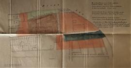
Copy map showing outline of the medieval St. Lawrence’s Chapel near the South Channel of the River Lee. The chapel is bounded by Webber’s Lane (now Morgan’s Lane) and by the ‘ascertained line of the Old City Wall’. The site was seemingly covered by the recently-demolished former Beamish & Crawford Brewery, Main Street South, Cork. The map was probably copied from a nineteenth-century lease map and has the following key to the coloured areas:
‘Land coloured red leased by Carleton & Mitchell to Francis Cottrell, 1st June 1796.
Green and brown leased by Carleton & Mitchell to Francis Cottrell, 1st June 1796.
Land coloured green held by Carleton under lease from Corporation dated May 6th 1706.
Land coloured brown held by Carleton under lease from Prebendary of Christ Church.
Land coloured blue held by Beamish & Crawford, surviving partners of “Beamish, Crawford & Barrett” as shewn on lease [of] Carleton & Mitchell to Cottrell dated 1st June 1796’.
With a typescript note by Fr. Angelus Healy OSFC on the history of St. Lawrence’s Church.

