Showing 6679 results

Archival description
Irish Capuchin Archives
Print preview Hierarchy View:

3217 results with digital objects Show results with digital objects

Manuscripts and Archival Texts

This series comprises a small collection of glass plate negative images of seventeenth century manuscripts and other original records pertaining to the lives, ministries, and writings of several early Irish Capuchins. These were acquired by Fr. Angelus Healy OFM Cap. (1875-1953) and Fr. Stanislaus Kavanagh OFM Cap. (1876-1965), another prominent Irish Capuchin historian, for research and publication purposes.

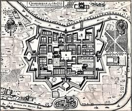
Map and Views of Charleville (now Charleville-Mézières) and Sedan, France

The file comprises ‘The Imperial Dry Plate Co., Ltd., Cricklewood, London’ box. The box contains three plates. One of the plates shows an image of a seventeenth century map of the town of Charleville (now Charleville-Mézières) in the Ardennes Department in Northern France. The map shows the location of the church and friary established by the exiled Irish Capuchins in Charleville in the early seventeenth century. The map is titled ‘Charleville sur le Bord de la Meuze dans la Principaute Souuerain Darches’. The map has been attributed to Edmé Moreau (1596-1648). The file also includes topographic views of the walled cities of Sedan and Tovl. A faint ink stamp of the British Museum is visible on the Sedan view. Includes a cover letter from Alan Macbeth, photographers, affirming that the prints were sourced from the ‘Zeillers Topographie Gallae’ collection in the British Museum. The letter is dated 2 January 1920.

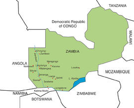
Map of Barotseland

Scale: 47.4 miles to 1 inch
Printed map of Barotseland, Northern Rhodesia, showing the principal districts and the Irish Capuchin mission stations primarily along the Zambezi River including Mongu, Sesheke and Katima Mulilo. The map is probably extracted from a government publication.

Map of Barotseland

Scale: 9 miles to 1 inch
Map of Barotse Province in Northern Rhodesia drawn by A.R. Stevens in 1930. The map shows the area from Balovale to Livingstone. The original key to the map shows the locations of mission stations established by the South African General Mission, the Seventh-Day Adventist Mission, the Plymouth Brethren Mission, and the Paris Evangelical Mission Society. Later endorsements on the map (in pencil) show major roads and railways and the locations of missions and schools founded by the Irish Capuchin friars.

Map of Cape Government Railways

No scale given
Fragmentary map of Cape Government Railways / The Royal Mail Route to the Orange River Colony, Transvaal, and Rhodesia. The map was printed by McCorquodale Ltd., Map Engravers, London. The map shows the principal railways in British possessions in Southern Africa including the Cape Colony, the Orange River Colony, Natal, Rhodesia (Zimbabwe) to the borders of Northern Rhodesia (Zambia). The territory is bordered to the north by ‘Portuguese possessions’ (Mozambique). A list of places mentioned on the map is included. Several ink-stamps of the ‘Vicariate, Eastern District, Cape of Good Hope’ are extant on the map.

Map of Capuchin properties on Church Street and Bow Street

The item is titled a ‘Rough map of premises on Church Street and Bow Street, Dublin, the property of the Capuchin Fathers’ by John L. Robinson, architect, 198 Great Brunswick Street, Dublin. The properties and lots are annotated with information relating to the dates and parties involved in various transactions. The parties included John Jameson, Viscount de Vesci and John Magrane. Information is given in respect of nos. 133-4 and 142 Church Street.

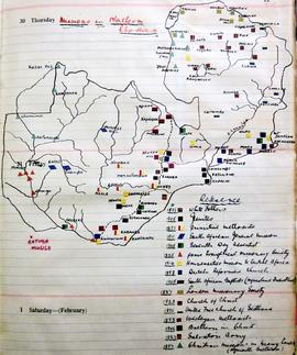
Map of Christian Missionary Stations in Northern Rhodesia

A manuscript map showing the locations of stations and churches founded by Christian (mainly Protestant) denominations in Northern Rhodesia (now Zambia). A reference key gives the dates of arrival of the various congregations and groups in the country. The map is extant on p. 11 in the volume.

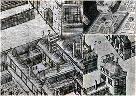
Map of Galway (c.1651)

A file containing ‘Wellington Plates’ box. The box holds four plates showing details from a pictorial map of Galway (c.1651). Two known copies of the original seventeenth century map exist, one in Trinity College Library in Dublin, and the second in the James Hardiman Library in NUI Galway.

The numbered map details include references to the following:

H. This is described on the map as the ‘Residentia Capuchinorum’. It represents a block of buildings on the north side of Great Gate Street in an area now known as Williamsgate Street. It sits under one of the Great Gates of the city (marked as ‘30’). It is most likely the location of the rented house occupied by the Capuchins in 1644 when they left the Collegiate buildings of St. Nicholas.

F. This indicates the altar erected by the Capuchins for public processions along the main thoroughfare running through Galway. The altar was situated at a place now popularly referred to as the ‘The Four Corners’, at one of which is the well-known fourteenth century stone townhouse called Lynch’s Castle (marked as ‘S’).

Number '8' on the map is a reference to a church, a block of buildings and an ornamental garden with walks. It is referred to on the map as ‘Capuchinorum Aedes’. It is situated outside the city walls and stands on the north side of Bohermore – now known as Prospect Hill. It is located near the old Pigeon House (marked as ‘42’). This is most likely the church and friary built by the Capuchins when they vacated their rented house in 1644. The site of this church is now occupied by The Western Hotel.

Map of Kafue National Park

Scale: 1 inch to 500,000 kms
Map of Kafue National Park in the Republic of Zambia. The map was published by the Zambian National Tourist Board in Lusaka.

Results 3971 to 3980 of 6679