Plan of ‘general arrangement of power house’ for the installation of electric lighting at the Capuchin Friary, Kilkenny. The name of the engineering firm is not given. With blueprint of the ‘stands for Vs type cells to be installed’.
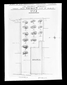
An plate showing an hand-drawn ‘plan of the Old Franciscan Capuchin Church in Church Street. Taken from Rocque’s map of Dublin, 1773’. The scale is given as 10 feet to 1 inch. This is presumably a plan of the original Capuchin chapel built on Church Street. It was replaced by a church built in 1796 which in turn was replaced by the existing Church of St. Mary of the Angels (built from 1868 to 1881). The plate is by Mayne, Lord Edward Street, Dublin.
Scale: ¼ inch to 1 foot Plan and sections for extension to the Capuchin Friary by Sylvester Bourke, architect, 79 High Street, Kilkenny. Includes first and second floor plans with details and sections of cells and washrooms. Sheet number: LO.14(A).
No scale given Architectural plan by John J. Robinson & R.C. Keefe, architects, 8 Merrion Square, Dublin, for heating works for the proposed extension and new library at the Capuchin Friary, Church Street. The plan shows heating arrangements for the ground, first and second floors
Plan for heating installation at Father Mathew Hall, Cork. Includes plans of the ground floor (stage, auditorium, foyer); mezzanine floor (balcony); first floor (billiard room, table tennis room, male and female dressing rooms and offices). Plan by John A. Deasy, consulting engineer, 16 Arran Quay, Dublin 7. The original plan is dated Apr. 1967 with revisions made in Mar. 1971.
Scale: ½ inch to 1 foot Plan and sections for extension to the Capuchin Novitiate at Kilkenny Friary by Sylvester Bourke, architect, 79 High Street, Kilkenny. Includes plans, sections and elevations of the study hall and various installations within the room. Sheet number: LO. /14(A).
Scale: 20 feet to 1 inch Plan of demised premises on Church Street bordered to the north by a passageway and by St. Mary of the Angels, to the west by a kiln, and to the south by a yard. The frontage onto Church Street measures 53 feet 4 inches and the total depth of the plot measures 262 feet.
Scale: 20 feet to 1 inch Plan by John Bowen, 68 St. Stephen’s Green, of demised plots fronting onto Bow Street. The demised premises are bordered to the north by St. Mary of the Angels and the adjoining Capuchin Friary and to the south by a corn kiln located at the rear of two dwelling houses on Church Street. With another plan of said premises endorsed with measurements.
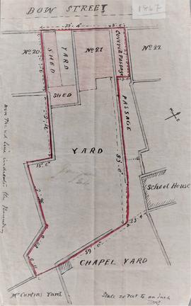
Scale: 20 feet to 1 inch Plan of premises at 21 Bow Street demised to the Capuchin friars drawn by C. Carmody, C.E., 29 Upper Ormond Quay, Dublin. The plot is bounded to north by 22 Bow Street, a passage way and a school house, and to the east by the Chapel Yard and Curtins’ Yard. The frontage onto Bow Street measures 38 feet 4 inches. An annotation on the reverse reads: ‘map of premises on Church Street upon part of which the Church Street Chapel is built’.
Scale: 20 feet to 1 inch Plan delineating the boundary of demised house, yards and shed at 21 Bow Street. The plot is bounded to north by 22 Bow Street, a passage way and a school house, and to the east by the Chapel Yard and Curtins’ Yard. The frontage onto Bow Street measures 38 feet 4 inches. An annotation in the left-hand margin of the plan reads: ‘The red line indicates the boundary’.