Imprimir vista previa Cerrar

Mostrando 845 resultados

Descripción archivística
Irish Capuchin Archives Irish Capuchin Archives Unidad documental simple Con objetos digitales
Imprimir vista previa Hierarchy Ver :

Lough Derg Pilgrims

A plate showing a group of pilgrims (some kneeling and barefooted) at devotions in front of the church on Lough Derg, County Donegal. The plate appears to have been hand-tinted and colourised. The plate also has a manuscript annotation.

Market Square, Westport, County Mayo

A view of the St. Patrick Monument and Market Square (also known as 'The Octagon') in Westport, Count Mayo. The plate has a manuscript caption. The image forms part of the Lawrence Photograph Collection. (National Library of Ireland: LROY 00137).

A Pauper, Cork

An image of a pauper dressed in a disheveled long coat with hat standing in an alley way in Cork city.

'Oceanic' Liner leaving Cork Harbour

A view of the White Star Liner ‘Oceanic’ leaving Queenstown (now Cobh) Harbour in 1905. Launched in 1899, it was largest ship in the world until 1901. At the outbreak of the First World War, the ship was requisitioned for service in the Royal Navy as an armed merchant cruiser. In September 1914, the ship ran aground off the coast of Shetland and was wrecked. She was the first Allied passenger ship to be lost in the war.

Fr. Mathew Inaugurates Temperance Campaign

A lantern slide showing a print of Fr. Theobald Mathew OSFC addressing a committee. The print is captioned ‘Here goes, in the name of God!, Fr. Mathew inaugurates the temperance campaign on 10 April 1838'. The drawing is by Denis Santry (1879-1960).

Father Mathew Pavilion, Cork International Exhibition

A view of the interior of the Father Mathew Pavilion at the Cork International Exhibition of 1902. The image shows a large decorative banner and models of Holy Trinity Church in Cork, and Thomastown Castle, County Tipperary, the childhood home of Fr. Mathew. The plate is captioned.

Copy map of St. Lawrence’s Chapel, Cork

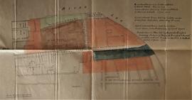
Copy map showing outline of the medieval St. Lawrence’s Chapel near the South Channel of the River Lee. The chapel is bounded by Webber’s Lane (now Morgan’s Lane) and by the ‘ascertained line of the Old City Wall’. The site was seemingly covered by the recently-demolished former Beamish & Crawford Brewery, Main Street South, Cork. The map was probably copied from a nineteenth-century lease map and has the following key to the coloured areas:
‘Land coloured red leased by Carleton & Mitchell to Francis Cottrell, 1st June 1796.
Green and brown leased by Carleton & Mitchell to Francis Cottrell, 1st June 1796.
Land coloured green held by Carleton under lease from Corporation dated May 6th 1706.
Land coloured brown held by Carleton under lease from Prebendary of Christ Church.
Land coloured blue held by Beamish & Crawford, surviving partners of “Beamish, Crawford & Barrett” as shewn on lease [of] Carleton & Mitchell to Cottrell dated 1st June 1796’.
With a typescript note by Fr. Angelus Healy OSFC on the history of St. Lawrence’s Church.

Resultados 101 a 110 de 845