Scale: 47.4 miles to 1 inch Printed map of Barotseland, Northern Rhodesia, showing the principal districts and the Irish Capuchin mission stations primarily along the Zambezi River including Mongu, Sesheke and Katima Mulilo. The map is probably extracted from a government publication.
Map of mission stations, out-schools in Barotseland primarily located along the Zambezi River. The location of local magistrate buildings and Protestant mission stations and schools is also given. The principal Irish Capuchin stations shown are Sancta Maria (Lukulu), Mongu, Schilli, Mankoya, and Livingstone.
Scale: 1 inch to 500,000 kms Map of Kafue National Park in the Republic of Zambia. The map was published by the Zambian National Tourist Board in Lusaka.
No scale given Copy map showing principal settlements and geographic and physical features of the Caprivi Strip bordered to the east by Zambia and to the west by Angola and Botswana. Attention is paid to the locations of mission stations and education establishments including at Katima Mulilo (founded by the Irish Capuchins) which has Mauvluma primary and Negweze schools.
Postcard print showing local children in Livingstone, Northern Rhodesia. The children are holding a sign which reads ‘Many thanks for Donation / God Bless You’.
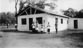
(On the right) Fr. Killian Flynn OFM Cap., Fr. Casimir Butler OFM Cap. (1876-1958) and altar servers outside Maramba Mission Church, Livingstone, Northern Rhodesia. The original caption reads ‘First mission chapel outside the centre of Livingstone, at Police Camp Maramba, opened on the Feast of Christ the King, 1932. A better church opened in Marmaba in 1940’.