Copy statement furnished by Fr. Peter Bowe OSFC, Provincial Minister, regarding the expenses incurred in the building and maintenance of the Sacred Heart Chapel which was built in 1908. The statement notes that the original estimate for the Chapel was £3,400. The statement provides details in respect of the installation and maintenance of heating, lightning, architect’s fees, and the cleaning and re-erecting of shrine altars.
Letter from J. Taylor, National Bank Limited, Dublin, to ‘Reverend Prior, Capuchin Friary, Church Street, Dublin’ enclosing ‘a short list of deeds … connected with Church St. solely’. With a typescript copy of said list.
Alphabetical index (by parties involved) to the title deeds, lease, indentures and other legal documents associated with properties held by the Capuchin friars, Church Street. The entries are listed under parties to the indenture, bundle and reference number and year. The manuscript may have been copied from the volume at CA CS/2/4/4.
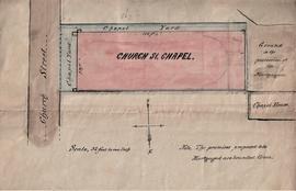
Scale: 32 feet to 1 inch
Plan of the Church Street Chapel bordered to the west by ground ‘in the possession of the mortgagors’ and the chapel house and to the east by the chapel yard fronting onto Church Street. The Chapel measures 164 feet by 58 feet. The plan was prepared by Terence O’Reilly & son, solicitors, 5 North Great George’s Street. The map is annotated: ‘The premises proposed to be mortgaged are bounded green’. The plan is also annotated on the reverse with a statement that the plan refers to the ‘Capuchin Loan’ and was sent to Messrs Blount on 22 June 1882.
Scale: 30 feet to 1 inch
Copy extract from the Ordnance Survey (1838) showing the Capuchin Chapel on Church Street bordered to north by Bedford Avenue (later Nicholas Avenue), to the south by May Lane, to the east by Bow Street and to the west by Church Street. An extract from a later Ordnance Survey map, copied in 1909, shows St. Mary of the Angels and the boundaries of Father Mathew Temperance Hall (constructed in 1890). One of the maps is annotated on the reverse ‘for Fr. Angelus Healy’.
Scale: 20 feet to 1 inch
Map of a plot of ground to be acquired for the Mary’s Lane Area Improvement Scheme by Dublin Corporation. The acquisition is to be enacted under the Housing of the Working Classes (Ireland), Acts, 1890-1921. The plot to be purchased is demarcated by a red border and is bounded to the east by Greek Street, to the west by Church Street, to the north by Mary’s Lane, and to the south by a portion of the Bridewell. The plot includes the tenements and premises located at nos. 27-38 Church Street. The southern portion of the plot is occupied by a copper works. A large portion of the frontage onto Greek Street is described as ruins. The map is given ‘Index no. 583’.
Architectural plans (in ink) by John J. Robinson & R.C. Keefe, architects, 8 Merrion Square, Dublin, of the proposed extension and new library at the Capuchin Friary, Church Street. The plan shows west-facing and east-facing elevations and several sections. Two plans with varying elevation. One plan is coloured in ink with coloured washes. See also CA CS/2/6/1/5.
Scale: ½ inch to 1 foot
Ground floor plan of St. Mary of the Angels, Church Street, by William A. Maguire & Associates, 34 Lower Baggot Street, Dublin 2. The project file number is noted as 251: drawing number 11. See section below titled Church and Friary Renovation 1970-1975.
Correspondence relating to estimates for the routine repair of boilers, roofing alterations to the Sacred Heart Chapel and other building works at the Capuchin Friary, Church Street. The file includes correspondence from Maguire and Gatchell Ltd., engineers, contractors & merchants, 7-15 Dawson Street, Dublin; Phoenix Sheet Metal Works, 8 Blessington Street, Dublin; E. Moneley, builder and contractor, 68 Blessington Street, Dublin; James J. Nolan, slater and general contactor, 27 Manor Street, Dublin.
