Floor Plan of St. Patrick’s Cathedral, Armagh
- IE CA PH/1/119
- Item
- c.1910
Parte de Irish Capuchin Archives
A plate showing an image of a print of the ground-floor plan of St. Patrick’s Cathedral, Armagh.
190 resultados com objetos digitais Mostrar resultados com objetos digitais
Floor Plan of St. Patrick’s Cathedral, Armagh
Parte de Irish Capuchin Archives
A plate showing an image of a print of the ground-floor plan of St. Patrick’s Cathedral, Armagh.
Parte de Irish Capuchin Archives
A view of an unidentified cleric sitting on a hillside with a coat and walking stick by his side.
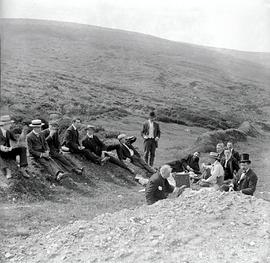
Picnic on Featherbed Mountain, County Dublin
Parte de Irish Capuchin Archives
Two plates showing an excursion and picnic on Featherbed Mountain in County Dublin. With an annotated cover. Fr. Thomas Dowling OSFC (1874-1951) is present in the photograph.
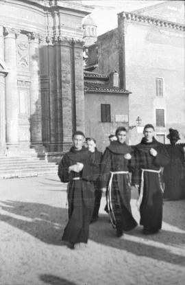
Observant Franciscans on a Piazza
Parte de Irish Capuchin Archives
A plate showing three Observant Franciscans (Order of Friars Minor) on a piazza probably in Italy. The plate is by Mayne, Lord Edward Street, Dublin.
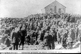
Dedication of Church, Croagh Patrick, County Mayo
Parte de Irish Capuchin Archives
A view of the dedication of the small church on top of Croagh Patrick in County Mayo which took place on 20 July 1905. The plate has a printed caption.
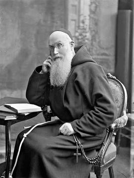
Fr. Paul Neary OSFC (1857-1939)
Parte de Irish Capuchin Archives
A studio portrait photograph of Fr. Paul Neary OSFC (1857-1939). With an annotated cover which reads ‘Fr. Paul, 2 B&W Carbons’.
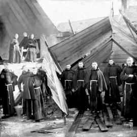
Capuchin Friars, Church Street, Dublin
Parte de Irish Capuchin Archives
A group of Capuchin friars (approximately eleven in total) standing in front of a partially ruined (or demolished) building. The image offers a rather abstract view of a group friars standing in front of a partially demolished building probably during construction work at the Church Street Friary, Dublin. Some of the friars are identifiable including Fr. Sylvester Mulligan OSFC (third from the right). Born in County Monaghan in 1875, he was educated at the Seraphic College at Rochestown in County Cork, before formally joining the Capuchins in 1892. He subsequently taught theology at the University of Louvain, Belgium, before undertaking missionary work in India. In 1937, he was appointed Archbishop of Delhi-Simla, the last non-Indian cleric to hold this position. He died in Dublin in 1950 and was buried in Glasnevin Cemetery.
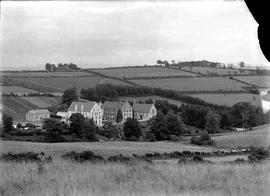
Rochestown Friary, County Cork
Parte de Irish Capuchin Archives
A file comprising three glass plates showing various views of Rochestown Capuchin Friary in County Cork.
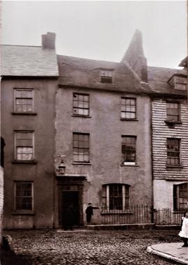
Parte de Irish Capuchin Archives
A view of ‘Cove Lane, Cork. The home of Fr. Theobald Mathew’. The plate is captioned.
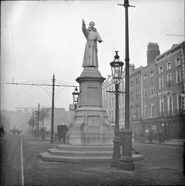
Father Theobald Mathew Statue, O'Connell Street, Dublin
Parte de Irish Capuchin Archives
A view of the statue of Fr. Theobald Mathew, the ‘Apostle of Temperance’, on Sackville Street (later O’Connell Street), Dublin. Tram lines are visible so the image can be dated to sometime after c.1896.