Print preview Close

Showing 98 results

Archival description
Item With digital objects Glass Plate Negative and Lantern Slide Collection
Print preview Hierarchy View:

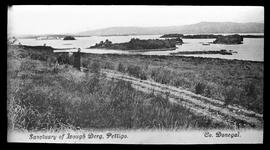
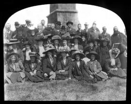
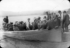
Lough Derg Pilgrims boarding a boat

A view of pilgrims boarding a small boat on their way to Lough Derg sanctuary in County Donegal. This is probably part of a collection of images which includes CA-PH-1-1 and CA-PH-1-15-16.

Man playing a Concertina

An unidentified bearded individual playing a concertina standing in front of a tapestry. He is wearing a long coat, a cap and has a walking stick. The individual may be a member of lay religious sodality.

Market Square, Westport, County Mayo

A view of the St. Patrick Monument and Market Square (also known as 'The Octagon') in Westport, Count Mayo. The plate has a manuscript caption. The image forms part of the Lawrence Photograph Collection. (National Library of Ireland: LROY 00137).

'Oceanic' Liner leaving Cork Harbour

A view of the White Star Liner ‘Oceanic’ leaving Queenstown (now Cobh) Harbour in 1905. Launched in 1899, it was largest ship in the world until 1901. At the outbreak of the First World War, the ship was requisitioned for service in the Royal Navy as an armed merchant cruiser. In September 1914, the ship ran aground off the coast of Shetland and was wrecked. She was the first Allied passenger ship to be lost in the war.

Old Capuchin Friary, Kilkenny

An exterior view of the old Capuchin Friary building on Walkin Street in Kilkenny. There appears to be scaffolding erected in the background. In December 1873, the foundation stone was laid for a new Friary running parallel to Walkin Street. In 1889 a lease was obtained for a small garden adjoining the Friary and in July 1896 the site of the old alms house was obtained from the Most Rev. Abraham Brownrigg (1836-1928), Bishop of Ossory. This allowed for the building of an additional wing to the Friary in 1897. This new wing was located at right angles to Walkin Street and extended to Pennyfeather Lane.

Plan of Old Capuchin Chapel, Church Street, Dublin

An plate showing an hand-drawn ‘plan of the Old Franciscan Capuchin Church in Church Street. Taken from Rocque’s map of Dublin, 1773’. The scale is given as 10 feet to 1 inch. This is presumably a plan of the original Capuchin chapel built on Church Street. It was replaced by a church built in 1796 which in turn was replaced by the existing Church of St. Mary of the Angels (built from 1868 to 1881). The plate is by Mayne, Lord Edward Street, Dublin.

Results 71 to 80 of 98