Affichage de 35 résultats

Description archivistique
Dossier Glass Plate Negative and Lantern Slide Collection
Aperçu avant impression Hierarchy Affichage :

17 résultats avec objets numériques Afficher les résultats avec des objets numériques

Provincial Chapter and Friar Groups

‘Kodak film wallet / MacSweeny’s Photographic Supply Store, Cork’. The file contains eight plates showing groups of Capuchins, including some images of friars at a Provincial Chapter in the Church Street Friary, Dublin. Includes images of Fr. Edwin Fitzgibbon OFM Cap. (1874-1938). Fr. Edwin was Provincial Minister from 1926-9 and from 1931-7.

Fr. Joseph Harkins OSFC (1853-1888)

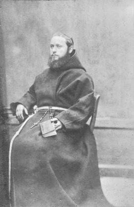
Two plates showing portraits of Fr. Joseph Harkins OSFC (1853-1888). This Kilkenny-born friar traveled to India in about 1884 and took charge of a mission in Meerut in Uttar Pradesh. He died in Meerut on 1 December 1888. The larger plate (10.5 cm x 8 cm) appears to a photographic print of a portrait painting. With an annotated cover.

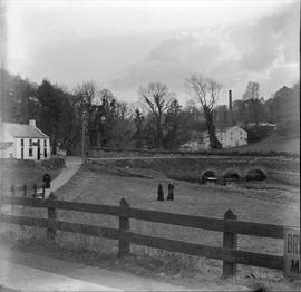
The Road from Rochestown, County Cork

Two plates showing images of the road from Rochestown to the local railway station. The image shows three Capuchin friars with a three-arch stone bridge, a mill and a chimney in the distant background. One of the friars is identifiable. The individual first on the right is Fr. Ignatius Collins OSFC. With an annotated cover.

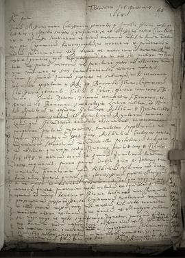
Acts of Professions of the Irish Capuchin Martyrs

A file containing three plates with images of the original acts of professions of two seventeenth century Irish Capuchin martyrs, Fr. Fiacre Tobin OSFC (c.1620-1656) and Fr. John Baptist Dowdall OSFC (c.1626-1710). The plates are labelled a-c. Fiacre Tobin’s profession is dated 2 July 1638. John Baptist Dowdall’s profession (at the Irish Capuchin friary in Charleville, France) is dated 5 October 1652.

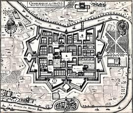
Map and Views of Charleville (now Charleville-Mézières) and Sedan, France

The file comprises ‘The Imperial Dry Plate Co., Ltd., Cricklewood, London’ box. The box contains three plates. One of the plates shows an image of a seventeenth century map of the town of Charleville (now Charleville-Mézières) in the Ardennes Department in Northern France. The map shows the location of the church and friary established by the exiled Irish Capuchins in Charleville in the early seventeenth century. The map is titled ‘Charleville sur le Bord de la Meuze dans la Principaute Souuerain Darches’. The map has been attributed to Edmé Moreau (1596-1648). The file also includes topographic views of the walled cities of Sedan and Tovl. A faint ink stamp of the British Museum is visible on the Sedan view. Includes a cover letter from Alan Macbeth, photographers, affirming that the prints were sourced from the ‘Zeillers Topographie Gallae’ collection in the British Museum. The letter is dated 2 January 1920.

Letters of Fr. Robert O’Connell OSFC (c.1623-1678)

A file containing ‘Criterion Plates Ltd., Stechford, Birmingham’ box. The box holds four plates. The annotation on the box reads ‘Negatives of letters of Fr. Robert O’Connell OSFC in the Fr. Luke Wadding OFM [1588-1657] collection'. The annotation was made by Fr. Stanislaus Kavanagh OFM Cap. in May 1922. The plates are labelled a-d.

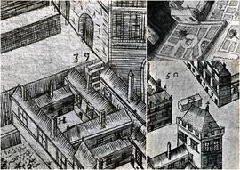
Map of Galway (c.1651)

A file containing ‘Wellington Plates’ box. The box holds four plates showing details from a pictorial map of Galway (c.1651). Two known copies of the original seventeenth century map exist, one in Trinity College Library in Dublin, and the second in the James Hardiman Library in NUI Galway.

The numbered map details include references to the following:

H. This is described on the map as the ‘Residentia Capuchinorum’. It represents a block of buildings on the north side of Great Gate Street in an area now known as Williamsgate Street. It sits under one of the Great Gates of the city (marked as ‘30’). It is most likely the location of the rented house occupied by the Capuchins in 1644 when they left the Collegiate buildings of St. Nicholas.

F. This indicates the altar erected by the Capuchins for public processions along the main thoroughfare running through Galway. The altar was situated at a place now popularly referred to as the ‘The Four Corners’, at one of which is the well-known fourteenth century stone townhouse called Lynch’s Castle (marked as ‘S’).

Number '8' on the map is a reference to a church, a block of buildings and an ornamental garden with walks. It is referred to on the map as ‘Capuchinorum Aedes’. It is situated outside the city walls and stands on the north side of Bohermore – now known as Prospect Hill. It is located near the old Pigeon House (marked as ‘42’). This is most likely the church and friary built by the Capuchins when they vacated their rented house in 1644. The site of this church is now occupied by The Western Hotel.

On the roadside near Rochestown, County Cork

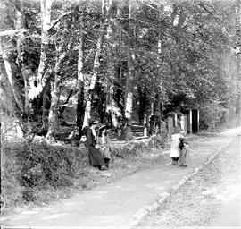
Two glass plates titled ‘On the roadside, Rochestown’. The cover annotation provides a date of 1906. The image is of two women (possibly a mother and daughter) greeting a group a children on a wooded path. The same women appear in the photograph at CA PH-1-29-D.

Landscapes and Views

A file containing eleven glass stereo plates of views of landscapes, scenery, and people. The images include:
33 (a) Three individuals on the roadside just overlooking the village of Raffeen in County Cork.
33 (b) A group of five individuals (probably a family group) collecting berries along the roadside.
33 (c) A portrait of a sitting woman with a cottage in the background.
33 (d) Four individuals working on the train line at Mageney Railway Station, County Kildare.
33 (e) A family group of seven individuals (two women and five children).
33 (f) A kneeling religious wearing a broad-brimmed hat cradling a young dog.
33 (g) A view of the Strawberry Beds in Dublin in about 1910.
33 (h) A woman wearing a long dress and a flat cap standing at a garden gate.
33 (i) Five dray horses standing harnessed to carts hauling large kegs at the Jameson Distillery, Bow Street, Dublin. A view of some of the working horses used at the Jameson Distillery, Bow Street, Dublin, in about 1910. The photograph was probably taken from atop of the old Capuchin Friary which fronted onto Bow Street.
33 (j) Two women (one sitting and holding a jug) on a forested hillside. The plate is missing a portion of the right-hand bottom corner.
33 (k) A large group of schoolchildren outside presumably a school building.

Irish Capuchin Friars and Locations

The file comprises ten plates and includes images of both individual Irish Capuchin friars and scenery and locations.
35 (a) A view of St. Mary of the Angels, Church Street, Dublin, from a slightly elevated position. The print shows the building before the addition of the Sacred Heart Chapel which was built as an aisle church in 1908. The caption refers to the ordination of Fr. Theobald Mathew OSFC (1790-1856) in the previous chapel on Church Street in 1809. With cover. A copy of this image is extant at CA-PH-1-71.
35 (b) Two plates of Fr. Berchmans Cantillon OFM Cap. (1880-1942). With cover.
35 (c) Two Capuchin friars and two dogs in the Church Street Friary garden. With annotated envelope suggesting that this is likely a poor quality image.
35 (d) Fr. Alphonsus Carroll OFM Cap. (1874-1934). With cover.
35 (e) Fr. Salvator Maria Corrigan OFM Cap. (1835-1919). The annotation on the cover suggests that this may be a poor quality image.
35 (f) An unidentified family group (six standing and five sitting or kneeling).
35 (g) Two plates of two separate and unidentified women. The annotated cover suggests that they are ‘Jenny & May’.
35 (h) An unidentified church and graveyard.

Résultats 1 à 10 sur 35