Showing 35 results

Archival description
File Glass Plate Negative and Lantern Slide Collection
Print preview Hierarchy View:

17 results with digital objects Show results with digital objects

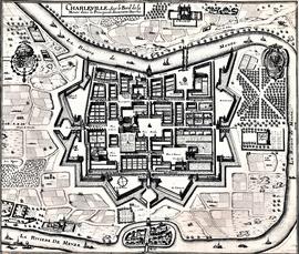
Map and Views of Charleville (now Charleville-Mézières) and Sedan, France

The file comprises ‘The Imperial Dry Plate Co., Ltd., Cricklewood, London’ box. The box contains three plates. One of the plates shows an image of a seventeenth century map of the town of Charleville (now Charleville-Mézières) in the Ardennes Department in Northern France. The map shows the location of the church and friary established by the exiled Irish Capuchins in Charleville in the early seventeenth century. The map is titled ‘Charleville sur le Bord de la Meuze dans la Principaute Souuerain Darches’. The map has been attributed to Edmé Moreau (1596-1648). The file also includes topographic views of the walled cities of Sedan and Tovl. A faint ink stamp of the British Museum is visible on the Sedan view. Includes a cover letter from Alan Macbeth, photographers, affirming that the prints were sourced from the ‘Zeillers Topographie Gallae’ collection in the British Museum. The letter is dated 2 January 1920.

Map of Galway (c.1651)

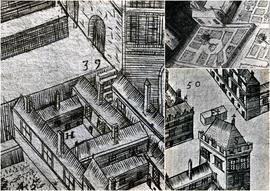
A file containing ‘Wellington Plates’ box. The box holds four plates showing details from a pictorial map of Galway (c.1651). Two known copies of the original seventeenth century map exist, one in Trinity College Library in Dublin, and the second in the James Hardiman Library in NUI Galway.

The numbered map details include references to the following:

H. This is described on the map as the ‘Residentia Capuchinorum’. It represents a block of buildings on the north side of Great Gate Street in an area now known as Williamsgate Street. It sits under one of the Great Gates of the city (marked as ‘30’). It is most likely the location of the rented house occupied by the Capuchins in 1644 when they left the Collegiate buildings of St. Nicholas.

F. This indicates the altar erected by the Capuchins for public processions along the main thoroughfare running through Galway. The altar was situated at a place now popularly referred to as the ‘The Four Corners’, at one of which is the well-known fourteenth century stone townhouse called Lynch’s Castle (marked as ‘S’).

Number '8' on the map is a reference to a church, a block of buildings and an ornamental garden with walks. It is referred to on the map as ‘Capuchinorum Aedes’. It is situated outside the city walls and stands on the north side of Bohermore – now known as Prospect Hill. It is located near the old Pigeon House (marked as ‘42’). This is most likely the church and friary built by the Capuchins when they vacated their rented house in 1644. The site of this church is now occupied by The Western Hotel.

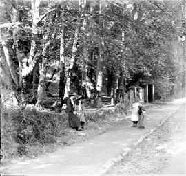
On the roadside near Rochestown, County Cork

Two glass plates titled ‘On the roadside, Rochestown’. The cover annotation provides a date of 1906. The image is of two women (possibly a mother and daughter) greeting a group a children on a wooded path. The same women appear in the photograph at CA PH-1-29-D.

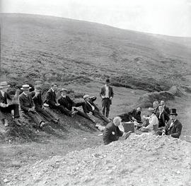
Provincial Chapter

‘Kodak film wallet / MacSweeny’s Photographic Supply Store, Cork’. The file contains two plates showing a group of Capuchin friars probably at a Provincial Chapter in the Church Street Friary. The group includes Fr. Edwin Fitzgibbon OFM Cap. (1874-1938). Fr. Edwin was Provincial Minister from 1926-9 and from 1931-7.

Provincial Chapter and Friar Groups

‘Kodak film wallet / MacSweeny’s Photographic Supply Store, Cork’. The file contains eight plates showing groups of Capuchins, including some images of friars at a Provincial Chapter in the Church Street Friary, Dublin. Includes images of Fr. Edwin Fitzgibbon OFM Cap. (1874-1938). Fr. Edwin was Provincial Minister from 1926-9 and from 1931-7.

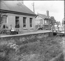
Rochestown Railway Station, County Cork

Two plates showing the small railway station at Rochestown in County Cork. Seven individuals are visible in the image including the station master and a woman nursing a young child. With an annotated cover.

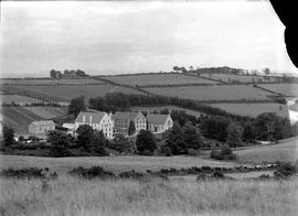
Scenes around Rochestown Capuchin Friary, County Cork

A collection of plates showing various scenes around Rochestown Capuchin Friary in County Cork. There are thirteen slides in the file. Duplicates of some of these plates are present in CA-PH-1-20.
26 (a): Two plates showing a view of the mill at Rochestown. With annotated cover.
26 (c): Interior of Rochestown Church. With annotated cover.
26 (d): Two women in the cemetery of Rochestown Friary. With annotated cover.
26 (e): Two plates showing the rear of Rochestown Friary with men tending a ploughed field.
26 (f): Two plates showing a front-view of Rochestown Friary and lake. The annotated cover provides a date of 1905.
26 (g): Two plates showing the fields and orchard behind Rochestown Friary. With annotated cover.
26 (h): Two plates showing two swans in the lake in front of Rochestown Friary. With annotated cover.

Scenes around the Capuchin Friary, Rochestown, County Cork

‘Paget Prize Plates – Lantern Slow’ box containing fourteen glass plates. The annotation on the front of the box reads: ‘Slides of road to monastery from station. To be mounted as stereo’. Contains seven stereo negative plates (fourteen in total) of scenes around the Capuchin Friary, Rochestown, County Cork. Includes one scene of a small tugboat at Queenstown Harbour, the mill on the road to Rochestown, and one of the Capuchin Friary at Rochestown.

Results 21 to 30 of 35